
Late January
Current Conditions:
Washington Pass: I was pleasantly surprised to find good quality dry snow above 6000′ on shaded aspects yesterday. There was wind effect in many alpine locations (still quite skiable), but more protected areas skied really well! Compared to last year, the snowpack is noticeably deeper. Total snow depth ranges from ~170cm on lower elevation solar aspects to well over 250cm in shaded northerly aspects, and this means that a lot of lines are really well filled in!
Stevens Pass: With last week’s storms Stevens Pass is now over a 100 inch base at 4,800′ and over 70 inches at 3,900′. We were lucky enough to have the vast majority of that precip fall as snow (barely). Stevens did pick up a freezing rain crust towards the end of the storm on Friday that made the skiing quite challenging.
Fortunately Stevens picked up another 4 inches of new snow on Saturday January 23rd that dramatically improved the skiing. Right now the best snow can be found on open slopes above 4,500 to 5,000′. The new snow had enough density to keep you off the freezing rain crust and is skiing quite well.
The trees took a major beating during this storm with a major tree bomb shed cycle (trees and large branches were falling as well). It will take quite a bit of snow to have the tree skiing recover. Best to stay in the open until we receive another 6 inches or more of snow.
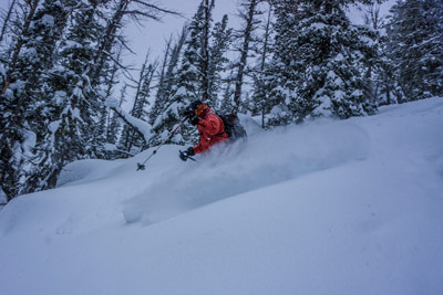
Rosty Shredding in the Silverstar area
Snowpack Observations:
The buried surface hoar layer was fairly widespread at and below treeline and has been quite sensitive, however last week’s storm gave it a good test. It is now buried 80cm to well over a meter deep in most areas and is showing signs of “healing”. That being said, we are still giving this layer some time and a wide margin until we get some more information about it. It was most prevalent on shaded aspects between 4,000′ and 5,000′ but could extend lower and higher depending on location, and was found on solar aspects as low as 3,000′. In our most recent tests, the surface hoar has not produced results, but we were finding moderate compression test results on a density change in the recent storm snow, typically down 40-50cm. The coming “atmospheric river” will give any remaining persistent weak layers another major load and while it might not help the ski quality, it will very likely add to our confidence in the snowpack (after temps cool down, of course!)
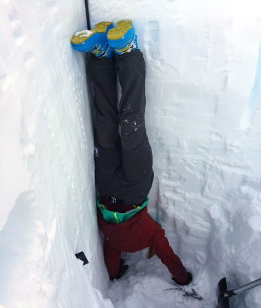
NCMG Guide Steph shows us how to take temperatures at the bottom of a 285cm full profile
Remotely triggered avalanche in the icicle creek area (Leavenworth)
Skiing Forecast:
The skiing should be pretty good through Tuesday if the easterly flow cooperates. Right now the forecast is calling for snow in the passes on Tuesday but it will be right on the verge of turning to rain Thursday looks quite wet and warm and you will have to go high to find good skiing. Friday it will start to cool off and continue to snow so the surface conditions should be good by the weekend.