
Mid December 2015
Current Conditions
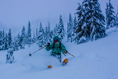
Washington Pass: It has been one of the best early seasons at Washington Pass in recent memory and the powder is even more appreciated after a lackluster season last year. While the lower elevations are still a bit brushy, they are well worth skiing with deep cold powder. The treeline elevations are downright amazing. I skied with a couple of other NCMG guides yesterday on a westerly aspect in the Washington Pass area and we all agreed that the combination of pow, visibility and terrain made it the best day of the season (hopefully so far!). Photo from December 14th in the WA Pass area
Stevens Pass: Jeff Ward and I taught an AIARE level 1 avalanche course at Stevens last weekend and agreed that the powder skiing enhanced our student’s learning significantly! The lower elevations are still quite thick with brush (Stevens has less snow than WA pass currently), but the upper elevations are skiing really well. With all lifts running, this is the perfect time to take advantage of the great conditions up high by utilizing lifts to access the backcountry with our off piste program. Photo from December 12th in the Stevens Pass backcountry.
Snowpack Observations
In both Washington Pass and Stevens Pass zones, the primary avalanche concerns are lingering storm slabs (all aspects and elevations) and wind slabs near ridge crest and in cross loaded features. There is more storm snow in the Washington Pass area so the slabs are a bit deeper and the expected size of avalanches potentially bigger. Yesterday in Washington Pass, we found storm slabs from 30 – 60cm depth that sheared cleanly within the storm snow in numerous hand shears (albeit with a fair amount of force required). Overall, the storm snow seemed well bonded to the underlying December rain / temperature crust. We skied some steeper (~40 degrees) small test slopes with no results. The wind slab observed was in very small isolated pockets near ridgetop (another group of NCMG guides reported similar wind slabs breaking 15-25cm deep in the Delancey zone). Overall, while we are starting to feel pretty good about the stability, we kept our terrain choices fairly conservative to avoid steeper terrain at ridgecrest, cross loaded features and avoided areas with poor runout. I feel confident that there are still some wind and storm slab problems out there, we just happened to avoid them yesterday. The skiing is great, the avalanche problems are manageable (e.g. storm slab and wind slab as opposed to dealing with a persistent weak layer) but it’s not open season.
We saw some sizeable debris piles from avalanches that ran during the December 9 / 10 warm up rain event (up to size D2.5) as well as some more recent smaller (D1) avalanches that appeared to be storm slabs and wind slabs. The more recent avalanches were running in steeper, rocky terrain.
This page is for informational purposes only and is no substitute for gathering your own observations in the field and checking the avalanche report at www.nwac.us.
Skiing Forecast
I could just write: “really, really good”…but here are the specifics. Tomorrow seems to be the day to get out in the sun, and then we return to snow showers and cool temps. Although we won’t be getting our vitamin D, this forecast is as good for our snowpack as it is for the skiing — we tend to form weak layers on the surface (which can become buried resulting in persistent weak layers) during extended periods of cold and clear weather, so a return to showery activity will mean renewed attention to the presence of wind slabs and possibly storm slabs and of course, powder skiing!